|
|
|||||||||||||||||
| Point ID: 6963 | Downloads | Plots | Site Data | Code: 11088 |
|
|
|||||||||||||||||
| Download | |
|---|---|
| Site Descriptor Information | Site Time Series Data |
| Link to all available data | |
| View: | Time Series | All |
| Units: | mm |
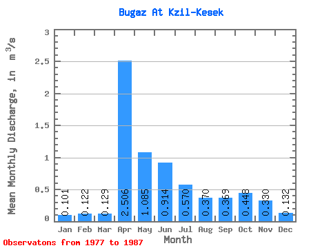
| Statistic | Jan | Feb | Mar | Apr | May | Jun | Jul | Aug | Sep | Oct | Nov | Dec | Annual |
|---|---|---|---|---|---|---|---|---|---|---|---|---|---|
| Mean | 0.10 | 0.12 | 0.13 | 2.51 | 1.08 | 0.91 | 0.57 | 0.37 | 0.37 | 0.45 | 0.33 | 0.13 | 0.76 |
| Standard Deviation | 0.07 | 0.01 | 0.05 | 2.49 | 0.97 | 0.68 | 0.46 | 0.28 | 0.35 | 0.39 | 0.14 | 0.03 | 0.41 |
| Min | 0.01 | 0.11 | 0.10 | 0.33 | 0.35 | 0.37 | 0.20 | 0.11 | 0.08 | 0.08 | 0.18 | 0.09 | 0.33 |
| Max | 0.19 | 0.13 | 0.20 | 6.76 | 2.88 | 1.94 | 1.66 | 1.06 | 1.28 | 1.47 | 0.50 | 0.16 | 1.15 |
| Coefficient of Variation | 0.65 | 0.08 | 0.37 | 0.99 | 0.90 | 0.74 | 0.80 | 0.76 | 0.94 | 0.87 | 0.41 | 0.26 | 0.54 |
 Return to R-Arctic Net Home Page