|
|
|||||||||||||||||
| Point ID: 696 | Downloads | Plots | Site Data | Code: 07CD004 |
|
|
|||||||||||||||||
| Download | |
|---|---|
| Site Descriptor Information | Site Time Series Data |
| Link to all available data | |
| View: | Time Series | All |
| Units: | mm |
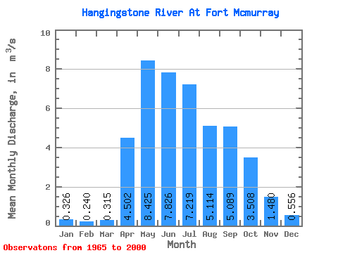
| Statistic | Jan | Feb | Mar | Apr | May | Jun | Jul | Aug | Sep | Oct | Nov | Dec | Annual |
|---|---|---|---|---|---|---|---|---|---|---|---|---|---|
| Mean | 0.33 | 0.24 | 0.32 | 4.50 | 8.43 | 7.83 | 7.22 | 5.11 | 5.09 | 3.51 | 1.48 | 0.56 | 3.96 |
| Standard Deviation | 0.14 | 0.12 | 0.21 | 4.41 | 5.67 | 5.96 | 6.06 | 5.95 | 5.62 | 2.55 | 0.74 | 0.25 | 1.71 |
| Min | 0.10 | 0.07 | 0.05 | 0.82 | 1.06 | 1.20 | 0.86 | 0.37 | 0.28 | 0.36 | 0.59 | 0.17 | 1.62 |
| Max | 0.59 | 0.41 | 1.22 | 20.00 | 19.80 | 29.50 | 28.30 | 25.50 | 20.50 | 8.60 | 3.12 | 1.25 | 8.11 |
| Coefficient of Variation | 0.43 | 0.49 | 0.66 | 0.98 | 0.67 | 0.76 | 0.84 | 1.16 | 1.10 | 0.73 | 0.50 | 0.45 | 0.43 |
 Return to R-Arctic Net Home Page