|
|
|||||||||||||||||
| Point ID: 6952 | Downloads | Plots | Site Data | Code: 11056 |
|
|
|||||||||||||||||
| Download | |
|---|---|
| Site Descriptor Information | Site Time Series Data |
| Link to all available data | |
| View: | Time Series | All |
| Units: | mm |
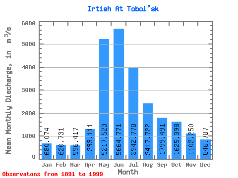
| Statistic | Jan | Feb | Mar | Apr | May | Jun | Jul | Aug | Sep | Oct | Nov | Dec | Annual |
|---|---|---|---|---|---|---|---|---|---|---|---|---|---|
| Mean | 680.07 | 620.73 | 596.42 | 1293.11 | 5217.52 | 5664.77 | 3942.78 | 2417.72 | 1799.49 | 1625.40 | 1102.25 | 846.79 | 2155.14 |
| Standard Deviation | 186.45 | 167.66 | 164.38 | 692.27 | 1400.63 | 1768.13 | 1608.11 | 1047.25 | 725.01 | 618.74 | 410.68 | 289.87 | 533.84 |
| Min | 340.00 | 173.00 | 313.00 | 409.00 | 2600.00 | 2240.00 | 1280.00 | 923.00 | 733.00 | 775.00 | 490.00 | 365.00 | 1232.33 |
| Max | 1270.00 | 1060.00 | 1040.00 | 4460.00 | 9990.00 | 10900.00 | 8720.00 | 6020.00 | 4220.00 | 4830.00 | 2470.00 | 1810.00 | 3898.25 |
| Coefficient of Variation | 0.27 | 0.27 | 0.28 | 0.54 | 0.27 | 0.31 | 0.41 | 0.43 | 0.40 | 0.38 | 0.37 | 0.34 | 0.25 |
 Return to R-Arctic Net Home Page