|
|
|||||||||||||||||
| Point ID: 6951 | Downloads | Plots | Site Data | Code: 11055 |
|
|
|||||||||||||||||
| Download | |
|---|---|
| Site Descriptor Information | Site Time Series Data |
| Link to all available data | |
| View: | Time Series | All |
| Units: | mm |
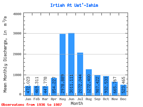
| Statistic | Jan | Feb | Mar | Apr | May | Jun | Jul | Aug | Sep | Oct | Nov | Dec | Annual |
|---|---|---|---|---|---|---|---|---|---|---|---|---|---|
| Mean | 472.02 | 469.31 | 447.78 | 854.23 | 2978.89 | 3011.11 | 2072.04 | 1272.40 | 987.42 | 932.53 | 665.77 | 523.47 | 1219.09 |
| Standard Deviation | 119.03 | 140.19 | 141.65 | 421.07 | 714.68 | 1073.30 | 949.79 | 558.07 | 316.57 | 303.76 | 221.76 | 163.69 | 322.08 |
| Min | 300.00 | 263.00 | 235.00 | 128.00 | 1690.00 | 1370.00 | 786.00 | 515.00 | 447.00 | 428.00 | 309.00 | 305.00 | 737.67 |
| Max | 797.00 | 808.00 | 787.00 | 2340.00 | 5020.00 | 6270.00 | 4860.00 | 3030.00 | 1860.00 | 2340.00 | 1520.00 | 1200.00 | 2172.58 |
| Coefficient of Variation | 0.25 | 0.30 | 0.32 | 0.49 | 0.24 | 0.36 | 0.46 | 0.44 | 0.32 | 0.33 | 0.33 | 0.31 | 0.26 |
 Return to R-Arctic Net Home Page