|
|
|||||||||||||||||
| Point ID: 6949 | Downloads | Plots | Site Data | Code: 11043 |
|
|
|||||||||||||||||
| Download | |
|---|---|
| Site Descriptor Information | Site Time Series Data |
| Link to all available data | |
| View: | Time Series | All |
| Units: | mm |
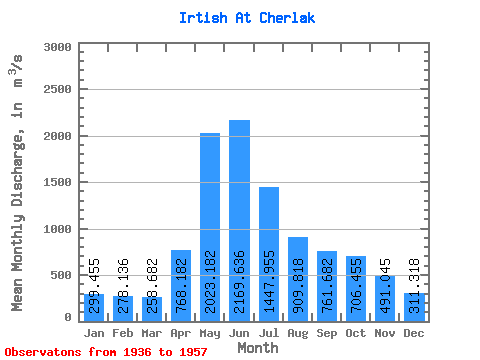
| Statistic | Jan | Feb | Mar | Apr | May | Jun | Jul | Aug | Sep | Oct | Nov | Dec | Annual |
|---|---|---|---|---|---|---|---|---|---|---|---|---|---|
| Mean | 299.45 | 278.14 | 258.68 | 768.18 | 2023.18 | 2169.64 | 1447.95 | 909.82 | 761.68 | 706.46 | 491.05 | 311.32 | 868.79 |
| Standard Deviation | 98.58 | 100.33 | 78.21 | 321.43 | 367.03 | 589.86 | 600.05 | 346.84 | 323.74 | 331.94 | 218.75 | 100.02 | 204.77 |
| Min | 191.00 | 159.00 | 152.00 | 294.00 | 1460.00 | 852.00 | 410.00 | 321.00 | 268.00 | 292.00 | 251.00 | 196.00 | 453.08 |
| Max | 579.00 | 613.00 | 507.00 | 1740.00 | 2960.00 | 3230.00 | 2900.00 | 1730.00 | 1770.00 | 1940.00 | 1220.00 | 580.00 | 1344.50 |
| Coefficient of Variation | 0.33 | 0.36 | 0.30 | 0.42 | 0.18 | 0.27 | 0.41 | 0.38 | 0.42 | 0.47 | 0.45 | 0.32 | 0.24 |
 Return to R-Arctic Net Home Page