|
|
|||||||||||||||||
| Point ID: 6948 | Downloads | Plots | Site Data | Other Close Sites | Code: 11037 |
|
|
|||||||||||||||||
| Download | |
|---|---|
| Site Descriptor Information | Site Time Series Data |
| Link to all available data | |
| View: | Time Series | All |
| Units: | mm |
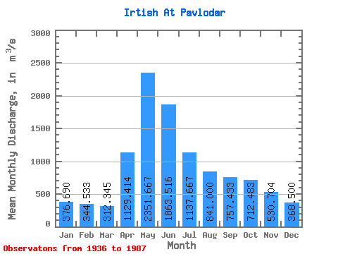
| Statistic | Jan | Feb | Mar | Apr | May | Jun | Jul | Aug | Sep | Oct | Nov | Dec | Annual |
|---|---|---|---|---|---|---|---|---|---|---|---|---|---|
| Mean | 376.69 | 344.53 | 312.35 | 1129.41 | 2351.67 | 1863.52 | 1137.67 | 841.00 | 757.43 | 712.48 | 530.70 | 368.50 | 886.85 |
| Standard Deviation | 128.16 | 122.75 | 86.63 | 377.13 | 578.91 | 789.66 | 517.19 | 318.52 | 308.62 | 236.83 | 204.94 | 154.09 | 185.07 |
| Min | 180.00 | 177.00 | 165.00 | 472.00 | 1220.00 | 574.00 | 452.00 | 420.00 | 374.00 | 410.00 | 216.00 | 219.00 | 505.08 |
| Max | 706.00 | 697.00 | 510.00 | 2080.00 | 3730.00 | 3420.00 | 2680.00 | 1670.00 | 1940.00 | 1650.00 | 1070.00 | 904.00 | 1300.58 |
| Coefficient of Variation | 0.34 | 0.36 | 0.28 | 0.33 | 0.25 | 0.42 | 0.46 | 0.38 | 0.41 | 0.33 | 0.39 | 0.42 | 0.21 |
| Other Close Sites | ||||||
|---|---|---|---|---|---|---|
| PointID | Latitude | Longitude | Drainage Area | Source | Name | |
| 7140 | "Irtish At Pavlodar" | 52.25 | -932209 | SHI | 2390.00 | |
 Return to R-Arctic Net Home Page