|
|
|||||||||||||||||
| Point ID: 6946 | Downloads | Plots | Site Data | Code: 11024 |
|
|
|||||||||||||||||
| Download | |
|---|---|
| Site Descriptor Information | Site Time Series Data |
| Link to all available data | |
| View: | Time Series | All |
| Units: | mm |
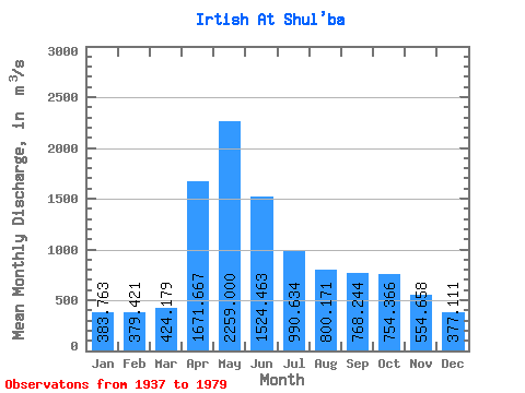
| Statistic | Jan | Feb | Mar | Apr | May | Jun | Jul | Aug | Sep | Oct | Nov | Dec | Annual |
|---|---|---|---|---|---|---|---|---|---|---|---|---|---|
| Mean | 383.76 | 379.42 | 424.18 | 1671.67 | 2259.00 | 1524.46 | 990.63 | 800.17 | 768.24 | 754.37 | 554.66 | 377.11 | 915.05 |
| Standard Deviation | 143.79 | 160.14 | 175.52 | 509.35 | 706.51 | 672.10 | 392.49 | 270.95 | 274.11 | 230.15 | 182.62 | 121.77 | 207.16 |
| Min | 189.00 | 181.00 | 196.00 | 713.00 | 1080.00 | 593.00 | 439.00 | 376.00 | 326.00 | 378.00 | 250.00 | 211.00 | 498.17 |
| Max | 735.00 | 848.00 | 978.00 | 2790.00 | 4040.00 | 3320.00 | 2300.00 | 1510.00 | 2100.00 | 1580.00 | 1020.00 | 705.00 | 1450.75 |
| Coefficient of Variation | 0.38 | 0.42 | 0.41 | 0.30 | 0.31 | 0.44 | 0.40 | 0.34 | 0.36 | 0.30 | 0.33 | 0.32 | 0.23 |
 Return to R-Arctic Net Home Page