|
|
|||||||||||||||||
| Point ID: 6943 | Downloads | Plots | Site Data | Code: 11001 |
|
|
|||||||||||||||||
| Download | |
|---|---|
| Site Descriptor Information | Site Time Series Data |
| Link to all available data | |
| View: | Time Series | All |
| Units: | mm |
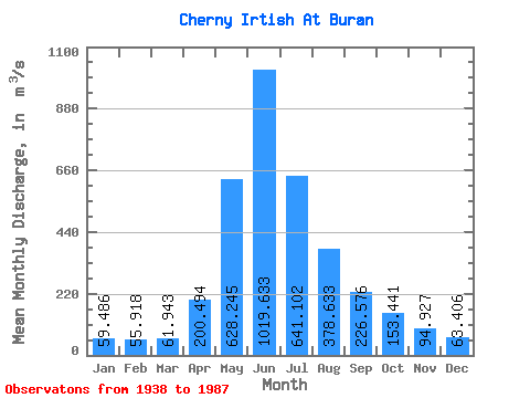
| Statistic | Jan | Feb | Mar | Apr | May | Jun | Jul | Aug | Sep | Oct | Nov | Dec | Annual |
|---|---|---|---|---|---|---|---|---|---|---|---|---|---|
| Mean | 59.49 | 55.92 | 61.94 | 200.49 | 628.25 | 1019.63 | 641.10 | 378.63 | 226.58 | 153.44 | 94.93 | 63.41 | 298.65 |
| Standard Deviation | 11.97 | 11.26 | 14.34 | 78.77 | 210.49 | 392.76 | 298.18 | 130.21 | 93.65 | 66.63 | 36.86 | 18.33 | 85.52 |
| Min | 39.80 | 37.10 | 41.70 | 52.30 | 192.00 | 284.00 | 138.00 | 176.00 | 91.90 | 73.10 | 53.50 | 37.90 | 133.55 |
| Max | 86.80 | 88.10 | 106.00 | 408.00 | 1060.00 | 1900.00 | 1540.00 | 791.00 | 507.00 | 480.00 | 292.00 | 115.00 | 478.27 |
| Coefficient of Variation | 0.20 | 0.20 | 0.23 | 0.39 | 0.34 | 0.39 | 0.47 | 0.34 | 0.41 | 0.43 | 0.39 | 0.29 | 0.29 |
 Return to R-Arctic Net Home Page