|
|
|||||||||||||||||
| Point ID: 6928 | Downloads | Plots | Site Data | Code: 10593 |
|
|
|||||||||||||||||
| Download | |
|---|---|
| Site Descriptor Information | Site Time Series Data |
| Link to all available data | |
| View: | Time Series | All |
| Units: | mm |
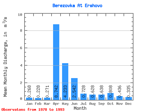
| Statistic | Jan | Feb | Mar | Apr | May | Jun | Jul | Aug | Sep | Oct | Nov | Dec | Annual |
|---|---|---|---|---|---|---|---|---|---|---|---|---|---|
| Mean | 0.27 | 0.23 | 0.27 | 8.74 | 4.23 | 2.54 | 0.73 | 0.63 | 0.64 | 0.81 | 0.44 | 0.34 | 1.66 |
| Standard Deviation | 0.10 | 0.07 | 0.16 | 4.37 | 2.75 | 5.32 | 0.64 | 0.41 | 0.35 | 0.44 | 0.12 | 0.10 | 0.74 |
| Min | 0.16 | 0.11 | 0.09 | 1.92 | 0.83 | 0.28 | 0.23 | 0.24 | 0.24 | 0.28 | 0.22 | 0.19 | 0.82 |
| Max | 0.54 | 0.37 | 0.72 | 17.70 | 10.40 | 20.10 | 2.42 | 1.54 | 1.15 | 1.68 | 0.63 | 0.58 | 3.62 |
| Coefficient of Variation | 0.37 | 0.32 | 0.58 | 0.50 | 0.65 | 2.10 | 0.89 | 0.65 | 0.55 | 0.54 | 0.28 | 0.31 | 0.45 |
 Return to R-Arctic Net Home Page