|
|
|||||||||||||||||
| Point ID: 6925 | Downloads | Plots | Site Data | Code: 10590 |
|
|
|||||||||||||||||
| Download | |
|---|---|
| Site Descriptor Information | Site Time Series Data |
| Link to all available data | |
| View: | Time Series | All |
| Units: | mm |
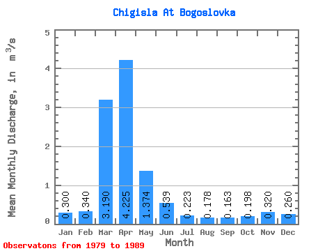
| Statistic | Jan | Feb | Mar | Apr | May | Jun | Jul | Aug | Sep | Oct | Nov | Dec | Annual |
|---|---|---|---|---|---|---|---|---|---|---|---|---|---|
| Mean | 0.30 | 0.34 | 3.19 | 4.22 | 1.37 | 0.54 | 0.22 | 0.18 | 0.16 | 0.20 | 0.32 | 0.26 | 1.30 |
| Standard Deviation | 0.53 | 1.16 | 0.46 | 0.12 | 0.08 | 0.07 | 0.08 | ||||||
| Min | 0.30 | 0.34 | 3.19 | 3.85 | 0.16 | 0.06 | 0.01 | 0.01 | 0.01 | 0.14 | 0.32 | 0.26 | 1.30 |
| Max | 0.30 | 0.34 | 3.19 | 4.60 | 3.65 | 1.60 | 0.46 | 0.28 | 0.24 | 0.35 | 0.32 | 0.26 | 1.30 |
| Coefficient of Variation | 0.13 | 0.85 | 0.85 | 0.55 | 0.43 | 0.41 | 0.39 |
 Return to R-Arctic Net Home Page