|
|
|||||||||||||||||
| Point ID: 6914 | Downloads | Plots | Site Data | Code: 10577 |
|
|
|||||||||||||||||
| Download | |
|---|---|
| Site Descriptor Information | Site Time Series Data |
| Link to all available data | |
| View: | Time Series | All |
| Units: | mm |
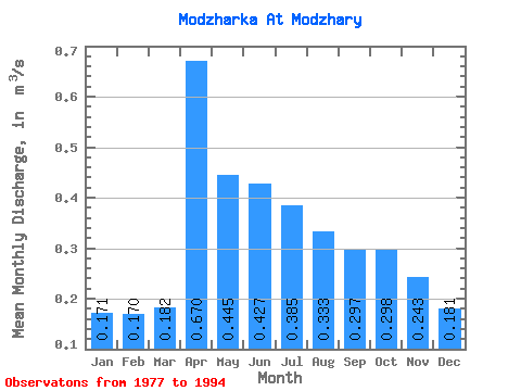
| Statistic | Jan | Feb | Mar | Apr | May | Jun | Jul | Aug | Sep | Oct | Nov | Dec | Annual |
|---|---|---|---|---|---|---|---|---|---|---|---|---|---|
| Mean | 0.17 | 0.17 | 0.18 | 0.67 | 0.45 | 0.43 | 0.39 | 0.33 | 0.30 | 0.30 | 0.24 | 0.18 | 0.33 |
| Standard Deviation | 0.06 | 0.06 | 0.05 | 0.55 | 0.23 | 0.20 | 0.19 | 0.17 | 0.14 | 0.16 | 0.14 | 0.09 | 0.14 |
| Min | 0.09 | 0.11 | 0.11 | 0.10 | 0.13 | 0.16 | 0.14 | 0.19 | 0.11 | 0.12 | 0.11 | 0.08 | 0.13 |
| Max | 0.28 | 0.28 | 0.25 | 2.14 | 0.88 | 0.77 | 0.87 | 0.84 | 0.71 | 0.83 | 0.68 | 0.40 | 0.58 |
| Coefficient of Variation | 0.34 | 0.34 | 0.30 | 0.83 | 0.52 | 0.47 | 0.48 | 0.49 | 0.45 | 0.55 | 0.58 | 0.47 | 0.41 |
 Return to R-Arctic Net Home Page