|
|
|||||||||||||||||
| Point ID: 6909 | Downloads | Plots | Site Data | Code: 10570 |
|
|
|||||||||||||||||
| Download | |
|---|---|
| Site Descriptor Information | Site Time Series Data |
| Link to all available data | |
| View: | Time Series | All |
| Units: | mm |
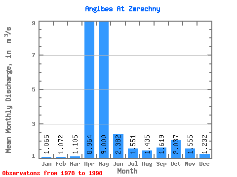
| Statistic | Jan | Feb | Mar | Apr | May | Jun | Jul | Aug | Sep | Oct | Nov | Dec | Annual |
|---|---|---|---|---|---|---|---|---|---|---|---|---|---|
| Mean | 1.06 | 1.07 | 1.10 | 8.96 | 9.00 | 2.38 | 1.55 | 1.44 | 1.62 | 2.04 | 1.56 | 1.23 | 3.06 |
| Standard Deviation | 0.38 | 0.43 | 0.51 | 4.13 | 7.28 | 1.18 | 0.46 | 0.67 | 0.72 | 0.78 | 0.62 | 0.34 | 0.74 |
| Min | 0.14 | 0.14 | 0.15 | 3.27 | 0.51 | 0.06 | 0.45 | 0.01 | 0.00 | 0.30 | 0.35 | 0.71 | 1.77 |
| Max | 1.54 | 1.66 | 1.73 | 16.70 | 24.60 | 4.12 | 2.16 | 2.86 | 3.00 | 3.49 | 2.93 | 1.67 | 4.54 |
| Coefficient of Variation | 0.36 | 0.40 | 0.47 | 0.46 | 0.81 | 0.49 | 0.30 | 0.47 | 0.44 | 0.38 | 0.40 | 0.27 | 0.24 |
 Return to R-Arctic Net Home Page