|
|
|||||||||||||||||
| Point ID: 6895 | Downloads | Plots | Site Data | Code: 10549 |
|
|
|||||||||||||||||
| Download | |
|---|---|
| Site Descriptor Information | Site Time Series Data |
| Link to all available data | |
| View: | Time Series | All |
| Units: | mm |
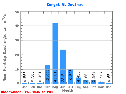
| Statistic | Jan | Feb | Mar | Apr | May | Jun | Jul | Aug | Sep | Oct | Nov | Dec | Annual |
|---|---|---|---|---|---|---|---|---|---|---|---|---|---|
| Mean | 0.56 | 0.51 | 0.49 | 13.01 | 41.62 | 23.54 | 10.51 | 4.42 | 2.66 | 2.55 | 1.56 | 0.65 | 9.53 |
| Standard Deviation | 3.02 | 2.76 | 2.55 | 9.58 | 88.21 | 43.87 | 19.45 | 9.67 | 5.61 | 6.20 | 5.15 | 2.85 | 15.42 |
| Min | 0.00 | 0.00 | 0.00 | 1.16 | 0.83 | 0.13 | 0.07 | 0.02 | 0.03 | 0.02 | 0.01 | 0.00 | 0.70 |
| Max | 22.30 | 19.80 | 18.30 | 52.30 | 682.00 | 293.00 | 97.60 | 56.00 | 28.60 | 33.30 | 38.30 | 21.60 | 105.22 |
| Coefficient of Variation | 5.34 | 5.46 | 5.19 | 0.74 | 2.12 | 1.86 | 1.85 | 2.19 | 2.11 | 2.43 | 3.29 | 4.36 | 1.62 |
 Return to R-Arctic Net Home Page