|
|
|||||||||||||||||
| Point ID: 6890 | Downloads | Plots | Site Data | Code: 10540 |
|
|
|||||||||||||||||
| Download | |
|---|---|
| Site Descriptor Information | Site Time Series Data |
| Link to all available data | |
| View: | Time Series | All |
| Units: | mm |
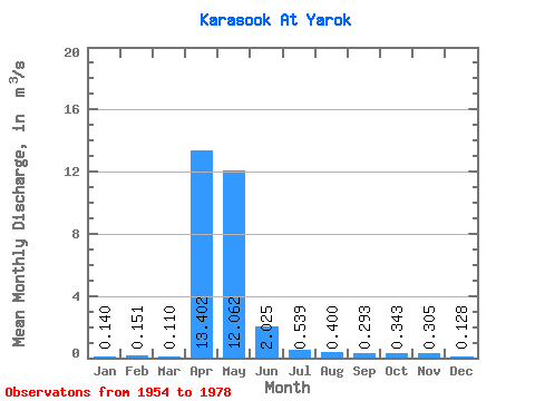
| Statistic | Jan | Feb | Mar | Apr | May | Jun | Jul | Aug | Sep | Oct | Nov | Dec | Annual |
|---|---|---|---|---|---|---|---|---|---|---|---|---|---|
| Mean | 0.14 | 0.15 | 0.11 | 13.40 | 12.06 | 2.02 | 0.54 | 0.40 | 0.29 | 0.34 | 0.30 | 0.13 | 2.65 |
| Standard Deviation | 0.22 | 0.21 | 0.17 | 16.38 | 9.58 | 1.38 | 0.46 | 0.54 | 0.47 | 0.47 | 0.29 | 0.17 | |
| Min | 0.01 | 0.00 | 0.00 | 0.06 | 1.96 | 0.12 | 0.10 | 0.01 | 0.01 | 0.00 | 0.02 | 0.00 | 2.65 |
| Max | 0.39 | 0.30 | 0.31 | 75.30 | 44.70 | 4.67 | 1.36 | 1.94 | 1.80 | 1.34 | 0.78 | 0.52 | 2.65 |
| Coefficient of Variation | 1.55 | 1.41 | 1.58 | 1.22 | 0.79 | 0.68 | 0.85 | 1.35 | 1.61 | 1.38 | 0.97 | 1.29 |
 Return to R-Arctic Net Home Page