|
|
|||||||||||||||||
| Point ID: 6889 | Downloads | Plots | Site Data | Code: 10539 |
|
|
|||||||||||||||||
| Download | |
|---|---|
| Site Descriptor Information | Site Time Series Data |
| Link to all available data | |
| View: | Time Series | All |
| Units: | mm |
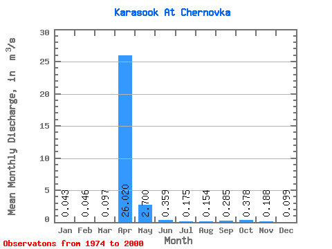
| Statistic | Jan | Feb | Mar | Apr | May | Jun | Jul | Aug | Sep | Oct | Nov | Dec | Annual |
|---|---|---|---|---|---|---|---|---|---|---|---|---|---|
| Mean | 0.04 | 0.05 | 0.10 | 26.02 | 2.70 | 0.36 | 0.17 | 0.15 | 0.28 | 0.38 | 0.19 | 0.10 | 2.75 |
| Standard Deviation | 0.03 | 0.03 | 0.14 | 20.48 | 3.34 | 0.33 | 0.14 | 0.15 | 0.28 | 0.27 | 0.09 | 0.06 | 2.34 |
| Min | 0.00 | 0.00 | 0.00 | 2.28 | 0.52 | 0.06 | 0.00 | 0.02 | 0.04 | 0.06 | 0.00 | 0.02 | 0.45 |
| Max | 0.11 | 0.10 | 0.57 | 71.10 | 13.90 | 1.34 | 0.53 | 0.49 | 1.15 | 1.05 | 0.35 | 0.23 | 7.36 |
| Coefficient of Variation | 0.73 | 0.69 | 1.50 | 0.79 | 1.24 | 0.91 | 0.82 | 0.95 | 0.97 | 0.72 | 0.50 | 0.64 | 0.85 |
 Return to R-Arctic Net Home Page