|
|
|||||||||||||||||
| Point ID: 6884 | Downloads | Plots | Site Data | Code: 10519 |
|
|
|||||||||||||||||
| Download | |
|---|---|
| Site Descriptor Information | Site Time Series Data |
| Link to all available data | |
| View: | Time Series | All |
| Units: | mm |
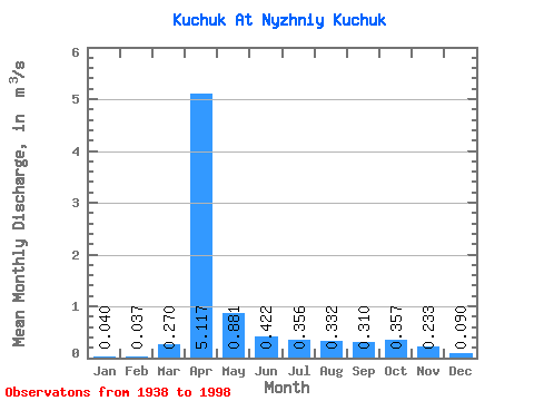
| Statistic | Jan | Feb | Mar | Apr | May | Jun | Jul | Aug | Sep | Oct | Nov | Dec | Annual |
|---|---|---|---|---|---|---|---|---|---|---|---|---|---|
| Mean | 0.04 | 0.04 | 0.27 | 5.12 | 0.88 | 0.42 | 0.36 | 0.33 | 0.31 | 0.36 | 0.23 | 0.09 | 0.81 |
| Standard Deviation | 0.04 | 0.04 | 0.57 | 4.26 | 0.47 | 0.14 | 0.18 | 0.15 | 0.10 | 0.15 | 0.15 | 0.05 | 0.43 |
| Min | 0.00 | 0.00 | 0.00 | 0.70 | 0.29 | 0.22 | 0.20 | 0.18 | 0.18 | 0.18 | 0.06 | 0.01 | 0.21 |
| Max | 0.14 | 0.15 | 2.40 | 22.40 | 2.26 | 0.80 | 1.36 | 1.07 | 0.79 | 1.10 | 0.99 | 0.23 | 2.19 |
| Coefficient of Variation | 0.89 | 1.05 | 2.10 | 0.83 | 0.54 | 0.34 | 0.50 | 0.46 | 0.32 | 0.43 | 0.63 | 0.58 | 0.54 |
 Return to R-Arctic Net Home Page