|
|
|||||||||||||||||
| Point ID: 6873 | Downloads | Plots | Site Data | Code: 10499 |
|
|
|||||||||||||||||
| Download | |
|---|---|
| Site Descriptor Information | Site Time Series Data |
| Link to all available data | |
| View: | Time Series | All |
| Units: | mm |
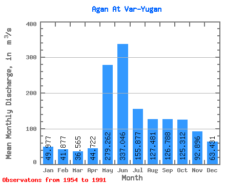
| Statistic | Jan | Feb | Mar | Apr | May | Jun | Jul | Aug | Sep | Oct | Nov | Dec | Annual |
|---|---|---|---|---|---|---|---|---|---|---|---|---|---|
| Mean | 49.98 | 41.88 | 36.56 | 44.72 | 279.26 | 337.05 | 155.88 | 127.48 | 126.79 | 125.31 | 92.90 | 63.43 | 121.29 |
| Standard Deviation | 16.08 | 12.93 | 11.03 | 19.06 | 108.67 | 147.10 | 69.48 | 78.25 | 64.06 | 63.49 | 44.42 | 26.02 | 30.22 |
| Min | 12.00 | 11.20 | 9.29 | 24.00 | 67.80 | 50.20 | 11.60 | 10.80 | 12.80 | 13.50 | 11.10 | 7.00 | 56.49 |
| Max | 73.50 | 67.50 | 55.60 | 125.00 | 499.00 | 584.00 | 361.00 | 389.00 | 253.00 | 272.00 | 186.00 | 116.00 | 166.36 |
| Coefficient of Variation | 0.32 | 0.31 | 0.30 | 0.43 | 0.39 | 0.44 | 0.45 | 0.61 | 0.51 | 0.51 | 0.48 | 0.41 | 0.25 |
 Return to R-Arctic Net Home Page