|
|
|||||||||||||||||
| Point ID: 6871 | Downloads | Plots | Site Data | Code: 10497 |
|
|
|||||||||||||||||
| Download | |
|---|---|
| Site Descriptor Information | Site Time Series Data |
| Link to all available data | |
| View: | Time Series | All |
| Units: | mm |
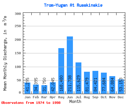
| Statistic | Jan | Feb | Mar | Apr | May | Jun | Jul | Aug | Sep | Oct | Nov | Dec | Annual |
|---|---|---|---|---|---|---|---|---|---|---|---|---|---|
| Mean | 41.30 | 34.40 | 31.75 | 42.05 | 168.48 | 211.74 | 115.63 | 81.48 | 84.42 | 77.68 | 64.88 | 53.15 | 83.17 |
| Standard Deviation | 13.38 | 9.69 | 8.95 | 29.98 | 65.94 | 83.05 | 38.82 | 31.91 | 35.56 | 41.20 | 32.60 | 28.72 | 19.93 |
| Min | 24.60 | 19.20 | 18.60 | 15.10 | 67.60 | 27.70 | 56.60 | 36.40 | 30.50 | 34.40 | 27.50 | 27.80 | 52.80 |
| Max | 82.90 | 55.90 | 51.10 | 146.00 | 331.00 | 328.00 | 185.00 | 181.00 | 170.00 | 218.00 | 171.00 | 150.00 | 130.92 |
| Coefficient of Variation | 0.32 | 0.28 | 0.28 | 0.71 | 0.39 | 0.39 | 0.34 | 0.39 | 0.42 | 0.53 | 0.50 | 0.54 | 0.24 |
 Return to R-Arctic Net Home Page