|
|
|||||||||||||||||
| Point ID: 6866 | Downloads | Plots | Site Data | Code: 10489 |
|
|
|||||||||||||||||
| Download | |
|---|---|
| Site Descriptor Information | Site Time Series Data |
| Link to all available data | |
| View: | Time Series | All |
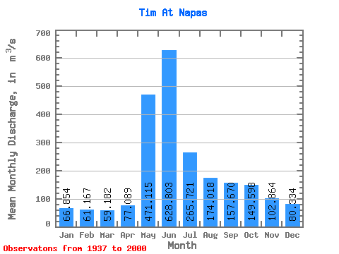
| Units: | mm |
| Statistic | Jan | Feb | Mar | Apr | May | Jun | Jul | Aug | Sep | Oct | Nov | Dec | Annual |
|---|---|---|---|---|---|---|---|---|---|---|---|---|---|
| Mean | 66.85 | 61.17 | 59.18 | 77.09 | 471.12 | 628.80 | 265.72 | 174.02 | 157.67 | 149.60 | 102.86 | 80.33 | 191.20 |
| Standard Deviation | 11.84 | 9.12 | 7.62 | 21.06 | 151.75 | 210.94 | 113.33 | 70.60 | 64.62 | 56.16 | 27.89 | 17.01 | 35.09 |
| Min | 44.30 | 39.90 | 39.40 | 50.40 | 159.00 | 264.00 | 135.00 | 90.80 | 83.30 | 72.60 | 56.90 | 52.50 | 133.11 |
| Max | 94.90 | 84.10 | 76.10 | 152.00 | 739.00 | 1060.00 | 730.00 | 444.00 | 400.00 | 301.00 | 168.00 | 123.00 | 282.07 |
| Coefficient of Variation | 0.18 | 0.15 | 0.13 | 0.27 | 0.32 | 0.34 | 0.43 | 0.41 | 0.41 | 0.38 | 0.27 | 0.21 | 0.18 |
 Return to R-Arctic Net Home Page