|
|
|||||||||||||||||
| Point ID: 6853 | Downloads | Plots | Site Data | Code: 10464 |
|
|
|||||||||||||||||
| Download | |
|---|---|
| Site Descriptor Information | Site Time Series Data |
| Link to all available data | |
| View: | Time Series | All |
| Units: | mm |
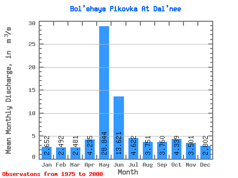
| Statistic | Jan | Feb | Mar | Apr | May | Jun | Jul | Aug | Sep | Oct | Nov | Dec | Annual |
|---|---|---|---|---|---|---|---|---|---|---|---|---|---|
| Mean | 2.65 | 2.49 | 2.48 | 4.24 | 28.84 | 13.62 | 4.62 | 3.75 | 3.76 | 4.34 | 3.50 | 2.80 | 6.46 |
| Standard Deviation | 0.65 | 0.55 | 0.64 | 2.35 | 10.90 | 7.85 | 1.54 | 1.45 | 1.39 | 1.58 | 1.30 | 0.72 | 1.69 |
| Min | 1.54 | 1.61 | 1.66 | 2.31 | 11.60 | 4.02 | 2.48 | 1.60 | 1.86 | 1.83 | 1.45 | 1.32 | 3.60 |
| Max | 4.63 | 3.51 | 3.90 | 10.50 | 45.70 | 29.30 | 7.56 | 7.24 | 6.79 | 6.80 | 6.07 | 4.58 | 9.40 |
| Coefficient of Variation | 0.24 | 0.22 | 0.26 | 0.56 | 0.38 | 0.58 | 0.33 | 0.39 | 0.37 | 0.36 | 0.37 | 0.26 | 0.26 |
 Return to R-Arctic Net Home Page