|
|
|||||||||||||||||
| Point ID: 6848 | Downloads | Plots | Site Data | Code: 10447 |
|
|
|||||||||||||||||
| Download | |
|---|---|
| Site Descriptor Information | Site Time Series Data |
| Link to all available data | |
| View: | Time Series | All |
| Units: | mm |
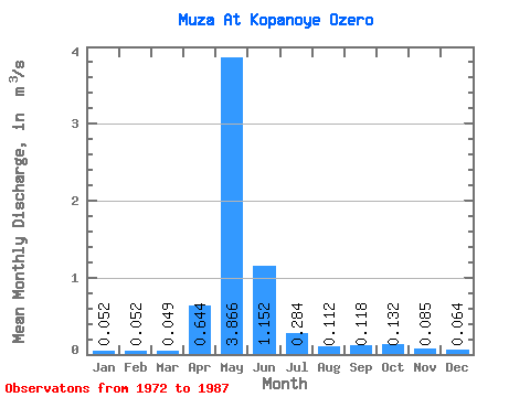
| Statistic | Jan | Feb | Mar | Apr | May | Jun | Jul | Aug | Sep | Oct | Nov | Dec | Annual |
|---|---|---|---|---|---|---|---|---|---|---|---|---|---|
| Mean | 0.05 | 0.05 | 0.05 | 0.64 | 3.87 | 1.15 | 0.28 | 0.11 | 0.12 | 0.13 | 0.09 | 0.06 | 0.54 |
| Standard Deviation | 0.02 | 0.02 | 0.02 | 0.70 | 3.17 | 0.97 | 0.41 | 0.06 | 0.08 | 0.08 | 0.04 | 0.02 | 0.35 |
| Min | 0.03 | 0.03 | 0.02 | 0.04 | 0.44 | 0.12 | 0.05 | 0.04 | 0.04 | 0.04 | 0.04 | 0.03 | 0.16 |
| Max | 0.09 | 0.09 | 0.09 | 2.32 | 10.20 | 3.61 | 1.77 | 0.29 | 0.38 | 0.36 | 0.16 | 0.12 | 1.17 |
| Coefficient of Variation | 0.35 | 0.40 | 0.40 | 1.09 | 0.82 | 0.84 | 1.45 | 0.49 | 0.66 | 0.58 | 0.42 | 0.35 | 0.65 |
 Return to R-Arctic Net Home Page