|
|
|||||||||||||||||
| Point ID: 6824 | Downloads | Plots | Site Data | Code: 10402 |
|
|
|||||||||||||||||
| Download | |
|---|---|
| Site Descriptor Information | Site Time Series Data |
| Link to all available data | |
| View: | Time Series | All |
| Units: | mm |
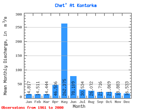
| Statistic | Jan | Feb | Mar | Apr | May | Jun | Jul | Aug | Sep | Oct | Nov | Dec | Annual |
|---|---|---|---|---|---|---|---|---|---|---|---|---|---|
| Mean | 14.82 | 14.51 | 14.44 | 46.51 | 262.38 | 78.11 | 30.53 | 26.07 | 21.72 | 21.87 | 18.88 | 16.53 | 47.20 |
| Standard Deviation | 3.14 | 3.63 | 3.50 | 32.98 | 101.95 | 46.46 | 10.03 | 12.17 | 6.76 | 6.93 | 6.03 | 4.57 | 13.17 |
| Min | 9.84 | 8.75 | 8.70 | 12.10 | 70.30 | 26.40 | 17.70 | 13.40 | 13.20 | 13.40 | 8.98 | 9.17 | 25.21 |
| Max | 22.30 | 23.80 | 25.30 | 126.00 | 579.00 | 210.00 | 56.00 | 65.80 | 41.10 | 40.60 | 33.90 | 27.00 | 90.39 |
| Coefficient of Variation | 0.21 | 0.25 | 0.24 | 0.71 | 0.39 | 0.59 | 0.33 | 0.47 | 0.31 | 0.32 | 0.32 | 0.28 | 0.28 |
 Return to R-Arctic Net Home Page