|
|
|||||||||||||||||
| Point ID: 6819 | Downloads | Plots | Site Data | Code: 10393 |
|
|
|||||||||||||||||
| Download | |
|---|---|
| Site Descriptor Information | Site Time Series Data |
| Link to all available data | |
| View: | Time Series | All |
| Units: | mm |
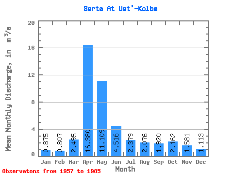
| Statistic | Jan | Feb | Mar | Apr | May | Jun | Jul | Aug | Sep | Oct | Nov | Dec | Annual |
|---|---|---|---|---|---|---|---|---|---|---|---|---|---|
| Mean | 0.88 | 0.81 | 2.50 | 16.38 | 11.11 | 4.52 | 2.38 | 2.08 | 1.92 | 2.16 | 1.58 | 1.11 | 3.94 |
| Standard Deviation | 0.47 | 0.46 | 7.49 | 8.09 | 6.40 | 3.31 | 1.63 | 1.32 | 1.10 | 0.95 | 0.80 | 0.54 | 1.38 |
| Min | 0.40 | 0.21 | 0.29 | 4.55 | 2.81 | 1.57 | 0.44 | 0.48 | 0.37 | 0.54 | 0.59 | 0.57 | 2.17 |
| Max | 2.24 | 2.20 | 39.80 | 36.20 | 24.80 | 15.50 | 6.87 | 4.79 | 4.64 | 4.30 | 4.36 | 2.81 | 7.02 |
| Coefficient of Variation | 0.53 | 0.57 | 3.00 | 0.49 | 0.58 | 0.73 | 0.68 | 0.63 | 0.57 | 0.44 | 0.51 | 0.49 | 0.35 |
 Return to R-Arctic Net Home Page