|
|
|||||||||||||||||
| Point ID: 6812 | Downloads | Plots | Site Data | Code: 10382 |
|
|
|||||||||||||||||
| Download | |
|---|---|
| Site Descriptor Information | Site Time Series Data |
| Link to all available data | |
| View: | Time Series | All |
| Units: | mm |
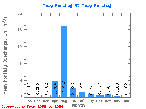
| Statistic | Jan | Feb | Mar | Apr | May | Jun | Jul | Aug | Sep | Oct | Nov | Dec | Annual |
|---|---|---|---|---|---|---|---|---|---|---|---|---|---|
| Mean | 0.11 | 0.08 | 0.08 | 3.76 | 16.96 | 2.33 | 1.20 | 0.77 | 0.57 | 0.76 | 0.39 | 0.16 | 2.29 |
| Standard Deviation | 0.08 | 0.07 | 0.07 | 4.16 | 6.72 | 1.72 | 2.27 | 1.17 | 0.62 | 0.84 | 0.37 | 0.11 | 0.61 |
| Min | 0.02 | 0.01 | 0.00 | 0.03 | 1.57 | 0.36 | 0.11 | 0.05 | 0.07 | 0.07 | 0.07 | 0.04 | 1.15 |
| Max | 0.40 | 0.38 | 0.25 | 13.30 | 27.00 | 8.43 | 13.40 | 4.92 | 2.26 | 4.46 | 1.80 | 0.47 | 3.64 |
| Coefficient of Variation | 0.73 | 0.88 | 0.80 | 1.11 | 0.40 | 0.74 | 1.89 | 1.51 | 1.08 | 1.10 | 0.95 | 0.67 | 0.27 |
 Return to R-Arctic Net Home Page