|
|
|||||||||||||||||
| Point ID: 6811 | Downloads | Plots | Site Data | Code: 10381 |
|
|
|||||||||||||||||
| Download | |
|---|---|
| Site Descriptor Information | Site Time Series Data |
| Link to all available data | |
| View: | Time Series | All |
| Units: | mm |
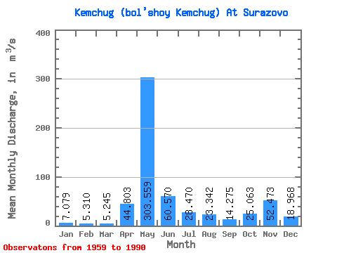
| Statistic | Jan | Feb | Mar | Apr | May | Jun | Jul | Aug | Sep | Oct | Nov | Dec | Annual |
|---|---|---|---|---|---|---|---|---|---|---|---|---|---|
| Mean | 7.08 | 5.31 | 5.25 | 44.80 | 303.56 | 60.57 | 28.47 | 23.34 | 14.28 | 25.06 | 52.47 | 18.97 | 49.26 |
| Standard Deviation | 9.21 | 5.65 | 7.39 | 54.52 | 173.16 | 38.78 | 27.62 | 29.87 | 9.47 | 33.71 | 127.67 | 39.66 | 15.97 |
| Min | 0.10 | 0.18 | 0.18 | 1.52 | 4.24 | 1.40 | 1.31 | 1.43 | 0.72 | 1.26 | 0.87 | 0.75 | 1.29 |
| Max | 47.40 | 30.90 | 42.40 | 183.00 | 652.00 | 156.00 | 107.00 | 138.00 | 36.30 | 168.00 | 531.00 | 141.00 | 74.50 |
| Coefficient of Variation | 1.30 | 1.06 | 1.41 | 1.22 | 0.57 | 0.64 | 0.97 | 1.28 | 0.66 | 1.34 | 2.43 | 2.09 | 0.32 |
 Return to R-Arctic Net Home Page