|
|
|||||||||||||||||
| Point ID: 6810 | Downloads | Plots | Site Data | Code: 10380 |
|
|
|||||||||||||||||
| Download | |
|---|---|
| Site Descriptor Information | Site Time Series Data |
| Link to all available data | |
| View: | Time Series | All |
| Units: | mm |
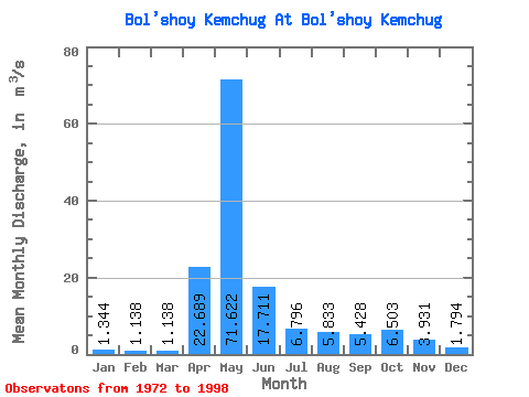
| Statistic | Jan | Feb | Mar | Apr | May | Jun | Jul | Aug | Sep | Oct | Nov | Dec | Annual |
|---|---|---|---|---|---|---|---|---|---|---|---|---|---|
| Mean | 1.34 | 1.14 | 1.14 | 22.69 | 71.62 | 17.71 | 6.80 | 5.83 | 5.43 | 6.50 | 3.93 | 1.79 | 12.16 |
| Standard Deviation | 0.39 | 0.35 | 0.29 | 17.03 | 28.40 | 9.72 | 4.28 | 6.70 | 4.32 | 3.81 | 2.61 | 0.71 | 2.67 |
| Min | 0.81 | 0.70 | 0.67 | 3.18 | 11.00 | 4.58 | 2.54 | 1.71 | 1.72 | 1.87 | 1.36 | 0.85 | 6.78 |
| Max | 2.13 | 2.03 | 1.71 | 62.10 | 118.00 | 44.40 | 18.40 | 33.90 | 18.70 | 15.60 | 9.52 | 3.30 | 15.59 |
| Coefficient of Variation | 0.29 | 0.31 | 0.26 | 0.75 | 0.40 | 0.55 | 0.63 | 1.15 | 0.80 | 0.59 | 0.67 | 0.40 | 0.22 |
 Return to R-Arctic Net Home Page