|
|
|||||||||||||||||
| Point ID: 6809 | Downloads | Plots | Site Data | Code: 10379 |
|
|
|||||||||||||||||
| Download | |
|---|---|
| Site Descriptor Information | Site Time Series Data |
| Link to all available data | |
| View: | Time Series | All |
| Units: | mm |
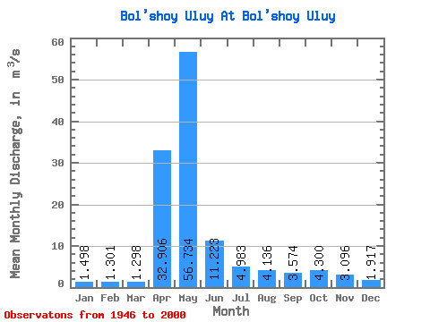
| Statistic | Jan | Feb | Mar | Apr | May | Jun | Jul | Aug | Sep | Oct | Nov | Dec | Annual |
|---|---|---|---|---|---|---|---|---|---|---|---|---|---|
| Mean | 1.50 | 1.30 | 1.30 | 32.91 | 56.73 | 11.22 | 4.98 | 4.14 | 3.57 | 4.30 | 3.10 | 1.92 | 10.61 |
| Standard Deviation | 0.47 | 0.46 | 0.61 | 20.92 | 33.65 | 5.66 | 3.76 | 3.30 | 1.85 | 2.13 | 2.39 | 0.69 | 2.79 |
| Min | 0.32 | 0.44 | 0.10 | 1.59 | 12.00 | 3.19 | 1.67 | 1.30 | 0.89 | 1.23 | 1.14 | 0.98 | 5.19 |
| Max | 2.45 | 2.31 | 3.98 | 89.70 | 197.00 | 24.20 | 20.90 | 17.40 | 10.20 | 10.20 | 16.70 | 3.90 | 19.56 |
| Coefficient of Variation | 0.31 | 0.35 | 0.47 | 0.64 | 0.59 | 0.51 | 0.76 | 0.80 | 0.52 | 0.49 | 0.77 | 0.36 | 0.26 |
 Return to R-Arctic Net Home Page