|
|
|||||||||||||||||
| Point ID: 6806 | Downloads | Plots | Site Data | Code: 10376 |
|
|
|||||||||||||||||
| Download | |
|---|---|
| Site Descriptor Information | Site Time Series Data |
| Link to all available data | |
| View: | Time Series | All |
| Units: | mm |
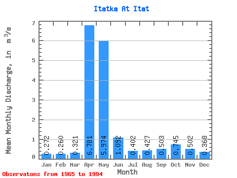
| Statistic | Jan | Feb | Mar | Apr | May | Jun | Jul | Aug | Sep | Oct | Nov | Dec | Annual |
|---|---|---|---|---|---|---|---|---|---|---|---|---|---|
| Mean | 0.27 | 0.26 | 0.32 | 6.78 | 5.97 | 1.09 | 0.40 | 0.43 | 0.50 | 0.74 | 0.50 | 0.37 | 1.52 |
| Standard Deviation | 0.12 | 0.11 | 0.20 | 3.17 | 3.90 | 0.69 | 0.30 | 0.42 | 0.35 | 0.45 | 0.26 | 0.17 | 0.40 |
| Min | 0.10 | 0.07 | 0.06 | 1.10 | 0.95 | 0.19 | 0.10 | 0.10 | 0.10 | 0.24 | 0.13 | 0.15 | 0.77 |
| Max | 0.52 | 0.47 | 1.17 | 13.60 | 14.80 | 2.67 | 1.13 | 2.09 | 1.43 | 2.06 | 1.25 | 0.88 | 2.33 |
| Coefficient of Variation | 0.44 | 0.41 | 0.62 | 0.47 | 0.65 | 0.63 | 0.74 | 0.98 | 0.69 | 0.60 | 0.53 | 0.47 | 0.26 |
 Return to R-Arctic Net Home Page