|
|
|||||||||||||||||
| Point ID: 6799 | Downloads | Plots | Site Data | Code: 10343 |
|
|
|||||||||||||||||
| Download | |
|---|---|
| Site Descriptor Information | Site Time Series Data |
| Link to all available data | |
| View: | Time Series | All |
| Units: | mm |
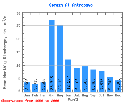
| Statistic | Jan | Feb | Mar | Apr | May | Jun | Jul | Aug | Sep | Oct | Nov | Dec | Annual |
|---|---|---|---|---|---|---|---|---|---|---|---|---|---|
| Mean | 3.61 | 3.02 | 3.59 | 26.95 | 25.19 | 12.21 | 9.11 | 9.66 | 8.47 | 7.88 | 5.74 | 4.30 | 9.98 |
| Standard Deviation | 2.62 | 2.04 | 2.74 | 14.09 | 28.12 | 7.37 | 5.54 | 8.75 | 6.78 | 6.31 | 4.97 | 3.42 | 5.04 |
| Min | 0.26 | 0.33 | 0.65 | 3.09 | 4.62 | 3.12 | 2.07 | 2.30 | 1.90 | 2.01 | 1.10 | 0.33 | 3.38 |
| Max | 12.30 | 8.88 | 12.70 | 59.20 | 187.00 | 31.30 | 29.90 | 49.80 | 34.40 | 32.20 | 25.90 | 16.50 | 27.59 |
| Coefficient of Variation | 0.73 | 0.68 | 0.77 | 0.52 | 1.12 | 0.60 | 0.61 | 0.91 | 0.80 | 0.80 | 0.86 | 0.79 | 0.51 |
 Return to R-Arctic Net Home Page