|
|
|||||||||||||||||
| Point ID: 6796 | Downloads | Plots | Site Data | Code: 10338 |
|
|
|||||||||||||||||
| Download | |
|---|---|
| Site Descriptor Information | Site Time Series Data |
| Link to all available data | |
| View: | Time Series | All |
| Units: | mm |
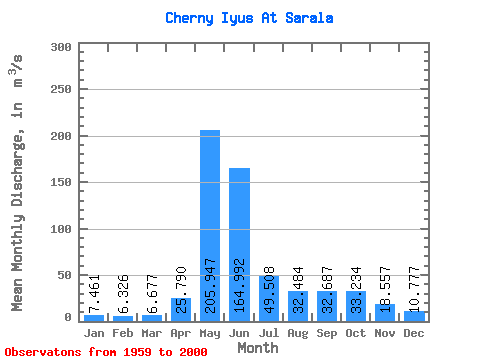
| Statistic | Jan | Feb | Mar | Apr | May | Jun | Jul | Aug | Sep | Oct | Nov | Dec | Annual |
|---|---|---|---|---|---|---|---|---|---|---|---|---|---|
| Mean | 7.46 | 6.33 | 6.68 | 25.79 | 205.95 | 164.99 | 49.51 | 32.48 | 32.69 | 33.23 | 18.56 | 10.78 | 49.54 |
| Standard Deviation | 1.46 | 1.57 | 1.19 | 13.32 | 46.26 | 75.68 | 21.36 | 11.29 | 13.84 | 13.57 | 7.87 | 2.86 | 8.79 |
| Min | 4.46 | 2.56 | 4.85 | 9.32 | 133.00 | 52.30 | 20.20 | 16.10 | 13.50 | 13.30 | 9.36 | 6.10 | 30.71 |
| Max | 10.40 | 9.43 | 9.90 | 59.30 | 309.00 | 325.00 | 140.00 | 56.80 | 68.40 | 70.90 | 48.80 | 21.80 | 67.92 |
| Coefficient of Variation | 0.20 | 0.25 | 0.18 | 0.52 | 0.23 | 0.46 | 0.43 | 0.35 | 0.42 | 0.41 | 0.42 | 0.27 | 0.18 |
 Return to R-Arctic Net Home Page