|
|
|||||||||||||||||
| Point ID: 6793 | Downloads | Plots | Site Data | Code: 10330 |
|
|
|||||||||||||||||
| Download | |
|---|---|
| Site Descriptor Information | Site Time Series Data |
| Link to all available data | |
| View: | Time Series | All |
| Units: | mm |
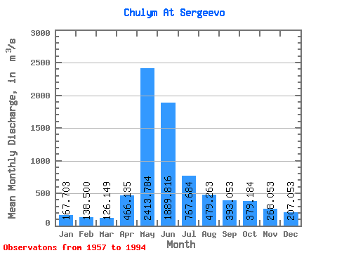
| Statistic | Jan | Feb | Mar | Apr | May | Jun | Jul | Aug | Sep | Oct | Nov | Dec | Annual |
|---|---|---|---|---|---|---|---|---|---|---|---|---|---|
| Mean | 167.70 | 138.50 | 126.15 | 466.13 | 2413.78 | 1889.82 | 767.68 | 479.26 | 393.05 | 379.18 | 268.05 | 207.05 | 640.80 |
| Standard Deviation | 33.38 | 26.02 | 21.71 | 263.17 | 524.55 | 716.38 | 274.96 | 158.13 | 98.59 | 87.01 | 66.34 | 39.35 | 128.51 |
| Min | 113.00 | 92.20 | 87.80 | 116.00 | 1190.00 | 764.00 | 339.00 | 255.00 | 236.00 | 239.00 | 158.00 | 142.00 | 410.50 |
| Max | 271.00 | 206.00 | 185.00 | 1290.00 | 3410.00 | 3400.00 | 1300.00 | 1010.00 | 660.00 | 581.00 | 408.00 | 326.00 | 890.00 |
| Coefficient of Variation | 0.20 | 0.19 | 0.17 | 0.56 | 0.22 | 0.38 | 0.36 | 0.33 | 0.25 | 0.23 | 0.25 | 0.19 | 0.20 |
 Return to R-Arctic Net Home Page