|
|
|||||||||||||||||
| Point ID: 6786 | Downloads | Plots | Site Data | Code: 10308 |
|
|
|||||||||||||||||
| Download | |
|---|---|
| Site Descriptor Information | Site Time Series Data |
| Link to all available data | |
| View: | Time Series | All |
| Units: | mm |
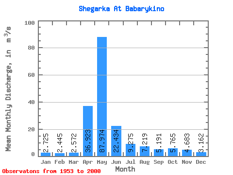
| Statistic | Jan | Feb | Mar | Apr | May | Jun | Jul | Aug | Sep | Oct | Nov | Dec | Annual |
|---|---|---|---|---|---|---|---|---|---|---|---|---|---|
| Mean | 2.73 | 2.44 | 2.57 | 36.92 | 87.97 | 22.43 | 9.28 | 7.22 | 5.19 | 5.76 | 4.68 | 3.16 | 15.86 |
| Standard Deviation | 1.10 | 0.92 | 0.97 | 40.03 | 76.66 | 21.09 | 13.24 | 7.95 | 3.04 | 4.10 | 2.88 | 1.35 | 10.19 |
| Min | 0.87 | 0.81 | 0.93 | 2.66 | 4.54 | 2.74 | 2.20 | 1.06 | 1.12 | 0.88 | 0.81 | 0.61 | 3.24 |
| Max | 5.58 | 4.77 | 5.83 | 219.00 | 300.00 | 105.00 | 79.60 | 50.80 | 18.10 | 21.40 | 14.80 | 7.85 | 44.25 |
| Coefficient of Variation | 0.41 | 0.38 | 0.38 | 1.08 | 0.87 | 0.94 | 1.43 | 1.10 | 0.59 | 0.71 | 0.61 | 0.43 | 0.64 |
 Return to R-Arctic Net Home Page