|
|
|||||||||||||||||
| Point ID: 6782 | Downloads | Plots | Site Data | Code: 10301 |
|
|
|||||||||||||||||
| Download | |
|---|---|
| Site Descriptor Information | Site Time Series Data |
| Link to all available data | |
| View: | Time Series | All |
| Units: | mm |
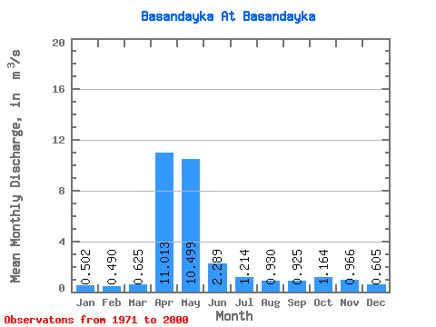
| Statistic | Jan | Feb | Mar | Apr | May | Jun | Jul | Aug | Sep | Oct | Nov | Dec | Annual |
|---|---|---|---|---|---|---|---|---|---|---|---|---|---|
| Mean | 0.50 | 0.49 | 0.62 | 11.01 | 10.50 | 2.29 | 1.21 | 0.93 | 0.93 | 1.16 | 0.97 | 0.60 | 2.60 |
| Standard Deviation | 0.14 | 0.16 | 0.23 | 5.84 | 6.57 | 1.57 | 0.77 | 0.47 | 0.42 | 0.52 | 0.39 | 0.17 | 0.76 |
| Min | 0.23 | 0.24 | 0.34 | 1.47 | 2.06 | 0.68 | 0.45 | 0.36 | 0.40 | 0.62 | 0.42 | 0.34 | 1.35 |
| Max | 0.92 | 1.02 | 1.21 | 27.40 | 25.50 | 9.10 | 3.44 | 2.04 | 2.15 | 2.91 | 1.91 | 0.97 | 4.32 |
| Coefficient of Variation | 0.29 | 0.32 | 0.37 | 0.53 | 0.63 | 0.69 | 0.63 | 0.50 | 0.45 | 0.45 | 0.41 | 0.28 | 0.29 |
 Return to R-Arctic Net Home Page