|
|
|||||||||||||||||
| Point ID: 6742 | Downloads | Plots | Site Data | Code: 10204 |
|
|
|||||||||||||||||
| Download | |
|---|---|
| Site Descriptor Information | Site Time Series Data |
| Link to all available data | |
| View: | Time Series | All |
| Units: | mm |
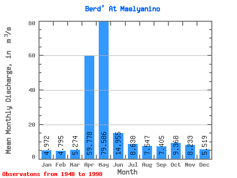
| Statistic | Jan | Feb | Mar | Apr | May | Jun | Jul | Aug | Sep | Oct | Nov | Dec | Annual |
|---|---|---|---|---|---|---|---|---|---|---|---|---|---|
| Mean | 4.97 | 4.79 | 5.27 | 59.78 | 79.59 | 14.96 | 8.64 | 7.55 | 7.41 | 9.37 | 8.23 | 5.52 | 17.94 |
| Standard Deviation | 1.76 | 1.71 | 1.82 | 35.90 | 50.25 | 8.51 | 3.70 | 3.38 | 2.88 | 3.42 | 2.95 | 1.98 | 5.01 |
| Min | 1.42 | 1.34 | 1.74 | 8.73 | 14.90 | 4.24 | 2.85 | 2.83 | 3.28 | 3.95 | 2.54 | 1.84 | 8.45 |
| Max | 9.03 | 8.93 | 9.25 | 155.00 | 219.00 | 41.20 | 17.80 | 16.20 | 13.70 | 20.00 | 18.50 | 11.10 | 31.10 |
| Coefficient of Variation | 0.35 | 0.36 | 0.34 | 0.60 | 0.63 | 0.57 | 0.43 | 0.45 | 0.39 | 0.36 | 0.36 | 0.36 | 0.28 |
 Return to R-Arctic Net Home Page