|
|
|||||||||||||||||
| Point ID: 674 | Downloads | Plots | Site Data | Code: 07BJ004 |
|
|
|||||||||||||||||
| Download | |
|---|---|
| Site Descriptor Information | Site Time Series Data |
| Link to all available data | |
| View: | Time Series | All |
| Units: | mm |
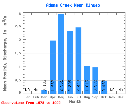
| Statistic | Jan | Feb | Mar | Apr | May | Jun | Jul | Aug | Sep | Oct | Nov | Dec | Annual |
|---|---|---|---|---|---|---|---|---|---|---|---|---|---|
| Mean | 0.14 | 1.96 | 2.95 | 2.31 | 2.45 | 1.01 | 0.97 | 0.46 | |||||
| Standard Deviation | 0.23 | 0.99 | 1.57 | 1.74 | 2.56 | 1.28 | 1.14 | 0.33 | |||||
| Min | 0.00 | 0.56 | 0.97 | 0.48 | 0.22 | 0.09 | 0.06 | 0.12 | |||||
| Max | 0.99 | 4.10 | 6.58 | 6.75 | 7.96 | 5.27 | 4.48 | 1.38 | |||||
| Coefficient of Variation | 1.66 | 0.51 | 0.53 | 0.76 | 1.05 | 1.26 | 1.17 | 0.70 |
 Return to R-Arctic Net Home Page