|
|
|||||||||||||||||
| Point ID: 672 | Downloads | Plots | Site Data | Code: 07BJ001 |
|
|
|||||||||||||||||
| Download | |
|---|---|
| Site Descriptor Information | Site Time Series Data |
| Link to all available data | |
| View: | Time Series | All |
| Units: | mm |
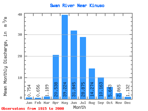
| Statistic | Jan | Feb | Mar | Apr | May | Jun | Jul | Aug | Sep | Oct | Nov | Dec | Annual |
|---|---|---|---|---|---|---|---|---|---|---|---|---|---|
| Mean | 0.75 | 0.66 | 1.19 | 20.54 | 39.22 | 31.84 | 28.88 | 14.27 | 10.16 | 5.64 | 2.87 | 1.13 | 13.46 |
| Standard Deviation | 0.46 | 0.47 | 1.46 | 12.22 | 27.96 | 23.21 | 22.44 | 14.36 | 10.10 | 3.98 | 1.48 | 0.65 | 5.00 |
| Min | 0.18 | 0.13 | 0.14 | 3.39 | 6.10 | 3.81 | 3.14 | 1.43 | 0.68 | 0.81 | 0.64 | 0.10 | 3.70 |
| Max | 1.58 | 1.78 | 9.12 | 53.20 | 167.00 | 129.00 | 99.80 | 64.60 | 42.60 | 20.80 | 6.18 | 2.36 | 27.13 |
| Coefficient of Variation | 0.61 | 0.71 | 1.23 | 0.59 | 0.71 | 0.73 | 0.78 | 1.01 | 0.99 | 0.70 | 0.52 | 0.58 | 0.37 |
 Return to R-Arctic Net Home Page