|
|
|||||||||||||||||
| Point ID: 6714 | Downloads | Plots | Site Data | Other Close Sites | Code: 10133 |
|
|
|||||||||||||||||
| Download | |
|---|---|
| Site Descriptor Information | Site Time Series Data |
| Link to all available data | |
| View: | Time Series | All |
| Units: | mm |
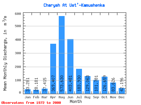
| Statistic | Jan | Feb | Mar | Apr | May | Jun | Jul | Aug | Sep | Oct | Nov | Dec | Annual |
|---|---|---|---|---|---|---|---|---|---|---|---|---|---|
| Mean | 33.28 | 28.18 | 37.41 | 369.41 | 573.63 | 403.48 | 183.93 | 129.06 | 101.78 | 126.66 | 83.63 | 42.20 | 176.05 |
| Standard Deviation | 6.45 | 5.81 | 13.18 | 120.10 | 117.13 | 168.35 | 68.72 | 65.28 | 39.42 | 55.56 | 39.39 | 14.97 | 34.20 |
| Min | 20.10 | 17.30 | 18.30 | 199.00 | 351.00 | 170.00 | 84.00 | 54.30 | 49.70 | 52.30 | 29.70 | 22.10 | 118.26 |
| Max | 48.10 | 39.60 | 68.10 | 678.00 | 799.00 | 794.00 | 328.00 | 310.00 | 246.00 | 259.00 | 200.00 | 74.40 | 256.12 |
| Coefficient of Variation | 0.19 | 0.21 | 0.35 | 0.33 | 0.20 | 0.42 | 0.37 | 0.51 | 0.39 | 0.44 | 0.47 | 0.35 | 0.19 |
| Other Close Sites | ||||||
|---|---|---|---|---|---|---|
| PointID | Latitude | Longitude | Drainage Area | Source | Name | |
| 6715 | "Charysh At Charishskiy Zernovoy Sovkhoz" | 52.13 | -483851 | SHI | 82.00 | |
 Return to R-Arctic Net Home Page