|
|
|||||||||||||||||
| Point ID: 6712 | Downloads | Plots | Site Data | Code: 10130 |
|
|
|||||||||||||||||
| Download | |
|---|---|
| Site Descriptor Information | Site Time Series Data |
| Link to all available data | |
| View: | Time Series | All |
| Units: | mm |
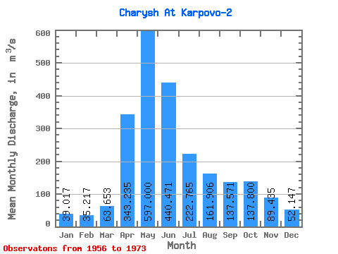
| Statistic | Jan | Feb | Mar | Apr | May | Jun | Jul | Aug | Sep | Oct | Nov | Dec | Annual |
|---|---|---|---|---|---|---|---|---|---|---|---|---|---|
| Mean | 39.02 | 35.22 | 63.65 | 343.24 | 597.00 | 440.47 | 222.76 | 161.91 | 137.57 | 137.80 | 89.44 | 52.15 | 193.43 |
| Standard Deviation | 13.49 | 11.95 | 34.84 | 94.19 | 153.96 | 179.62 | 79.52 | 66.90 | 52.17 | 53.22 | 34.92 | 25.60 | 34.05 |
| Min | 23.50 | 16.70 | 23.20 | 171.00 | 331.00 | 165.00 | 122.00 | 68.10 | 77.10 | 68.20 | 34.40 | 23.90 | 141.12 |
| Max | 65.40 | 58.70 | 144.00 | 528.00 | 913.00 | 782.00 | 439.00 | 278.00 | 260.00 | 274.00 | 152.00 | 111.00 | 254.97 |
| Coefficient of Variation | 0.35 | 0.34 | 0.55 | 0.27 | 0.26 | 0.41 | 0.36 | 0.41 | 0.38 | 0.39 | 0.39 | 0.49 | 0.18 |
 Return to R-Arctic Net Home Page