|
|
|||||||||||||||||
| Point ID: 6705 | Downloads | Plots | Site Data | Code: 10117 |
|
|
|||||||||||||||||
| Download | |
|---|---|
| Site Descriptor Information | Site Time Series Data |
| Link to all available data | |
| View: | Time Series | All |
| Units: | mm |
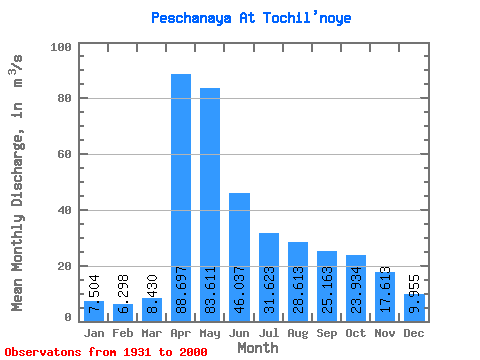
| Statistic | Jan | Feb | Mar | Apr | May | Jun | Jul | Aug | Sep | Oct | Nov | Dec | Annual |
|---|---|---|---|---|---|---|---|---|---|---|---|---|---|
| Mean | 7.50 | 6.30 | 8.43 | 88.70 | 83.61 | 46.04 | 31.62 | 28.61 | 25.16 | 23.93 | 17.61 | 9.96 | 31.50 |
| Standard Deviation | 2.96 | 2.59 | 4.25 | 34.26 | 42.56 | 23.47 | 17.01 | 17.34 | 14.95 | 12.56 | 10.28 | 4.63 | 9.69 |
| Min | 2.71 | 2.65 | 2.83 | 26.50 | 26.10 | 11.00 | 6.16 | 4.61 | 5.14 | 7.93 | 5.90 | 2.89 | 13.29 |
| Max | 17.10 | 15.60 | 25.50 | 174.00 | 235.00 | 114.00 | 90.90 | 103.00 | 84.20 | 66.60 | 59.00 | 25.60 | 63.67 |
| Coefficient of Variation | 0.39 | 0.41 | 0.50 | 0.39 | 0.51 | 0.51 | 0.54 | 0.61 | 0.59 | 0.53 | 0.58 | 0.47 | 0.31 |
 Return to R-Arctic Net Home Page