|
|
|||||||||||||||||
| Point ID: 6695 | Downloads | Plots | Site Data | Code: 10091 |
|
|
|||||||||||||||||
| Download | |
|---|---|
| Site Descriptor Information | Site Time Series Data |
| Link to all available data | |
| View: | Time Series | All |
| Units: | mm |
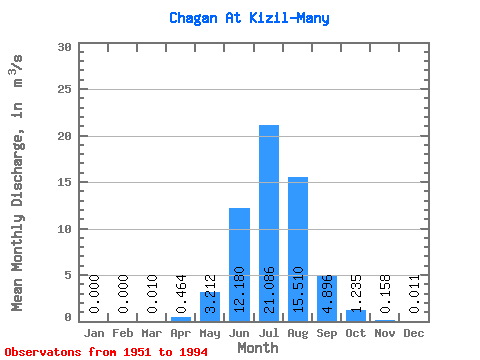
| Statistic | Jan | Feb | Mar | Apr | May | Jun | Jul | Aug | Sep | Oct | Nov | Dec | Annual |
|---|---|---|---|---|---|---|---|---|---|---|---|---|---|
| Mean | 0.00 | 0.00 | 0.01 | 0.46 | 3.21 | 12.18 | 21.09 | 15.51 | 4.90 | 1.23 | 0.16 | 0.01 | 4.95 |
| Standard Deviation | 0.00 | 0.00 | 0.03 | 0.55 | 2.37 | 6.02 | 7.00 | 5.05 | 2.66 | 0.58 | 0.13 | 0.02 | 0.77 |
| Min | 0.00 | 0.00 | 0.00 | 0.00 | 0.38 | 1.86 | 4.59 | 7.83 | 1.25 | 0.26 | 0.01 | 0.00 | 3.93 |
| Max | 0.00 | 0.00 | 0.09 | 2.98 | 9.54 | 31.90 | 35.90 | 31.70 | 10.80 | 2.84 | 0.42 | 0.05 | 6.22 |
| Coefficient of Variation | 2.85 | 1.18 | 0.74 | 0.49 | 0.33 | 0.33 | 0.54 | 0.47 | 0.81 | 1.72 | 0.16 |
 Return to R-Arctic Net Home Page