|
|
|||||||||||||||||
| Point ID: 6694 | Downloads | Plots | Site Data | Code: 10086 |
|
|
|||||||||||||||||
| Download | |
|---|---|
| Site Descriptor Information | Site Time Series Data |
| Link to all available data | |
| View: | Time Series | All |
| Units: | mm |
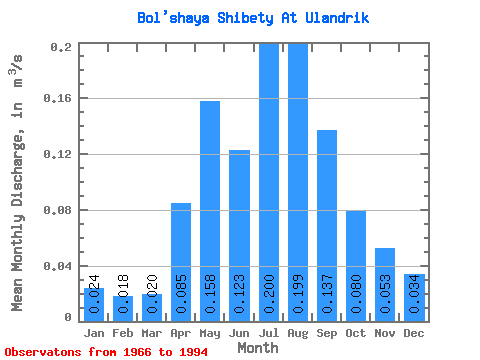
| Statistic | Jan | Feb | Mar | Apr | May | Jun | Jul | Aug | Sep | Oct | Nov | Dec | Annual |
|---|---|---|---|---|---|---|---|---|---|---|---|---|---|
| Mean | 0.02 | 0.02 | 0.02 | 0.09 | 0.16 | 0.12 | 0.20 | 0.20 | 0.14 | 0.08 | 0.05 | 0.03 | 0.12 |
| Standard Deviation | 0.01 | 0.01 | 0.01 | 0.13 | 0.19 | 0.15 | 0.32 | 0.32 | 0.20 | 0.08 | 0.04 | 0.02 | 0.11 |
| Min | 0.01 | 0.01 | 0.01 | 0.01 | 0.02 | 0.01 | 0.01 | 0.01 | 0.01 | 0.01 | 0.01 | 0.01 | 0.02 |
| Max | 0.04 | 0.02 | 0.03 | 0.50 | 0.61 | 0.49 | 1.35 | 1.16 | 0.76 | 0.24 | 0.17 | 0.08 | 0.36 |
| Coefficient of Variation | 0.34 | 0.29 | 0.26 | 1.48 | 1.22 | 1.20 | 1.60 | 1.62 | 1.46 | 0.95 | 0.79 | 0.64 | 0.94 |
 Return to R-Arctic Net Home Page