|
|
|||||||||||||||||
| Point ID: 6691 | Downloads | Plots | Site Data | Code: 10081 |
|
|
|||||||||||||||||
| Download | |
|---|---|
| Site Descriptor Information | Site Time Series Data |
| Link to all available data | |
| View: | Time Series | All |
| Units: | mm |
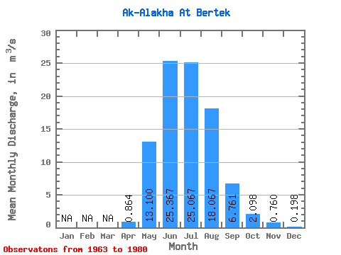
| Statistic | Jan | Feb | Mar | Apr | May | Jun | Jul | Aug | Sep | Oct | Nov | Dec | Annual |
|---|---|---|---|---|---|---|---|---|---|---|---|---|---|
| Mean | 0.86 | 13.10 | 25.37 | 25.07 | 18.07 | 6.76 | 2.10 | 0.76 | 0.20 | ||||
| Standard Deviation | 1.21 | 6.31 | 7.87 | 3.27 | 2.55 | 2.05 | 1.08 | 0.21 | 0.14 | ||||
| Min | 0.01 | 5.75 | 18.30 | 19.00 | 14.90 | 3.69 | 0.15 | 0.46 | 0.02 | ||||
| Max | 3.33 | 25.00 | 41.30 | 28.40 | 22.50 | 10.10 | 3.52 | 1.02 | 0.40 | ||||
| Coefficient of Variation | 1.40 | 0.48 | 0.31 | 0.13 | 0.14 | 0.30 | 0.51 | 0.28 | 0.71 |
 Return to R-Arctic Net Home Page