|
|
|||||||||||||||||
| Point ID: 669 | Downloads | Plots | Site Data | Code: 07BG004 |
|
|
|||||||||||||||||
| Download | |
|---|---|
| Site Descriptor Information | Site Time Series Data |
| Link to all available data | |
| View: | Time Series | All |
| Units: | mm |
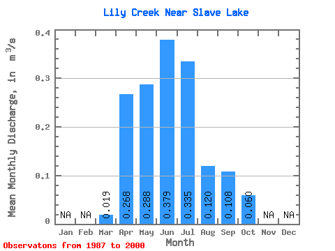
| Statistic | Jan | Feb | Mar | Apr | May | Jun | Jul | Aug | Sep | Oct | Nov | Dec | Annual |
|---|---|---|---|---|---|---|---|---|---|---|---|---|---|
| Mean | 0.02 | 0.27 | 0.29 | 0.38 | 0.34 | 0.12 | 0.11 | 0.06 | |||||
| Standard Deviation | 0.03 | 0.21 | 0.16 | 0.24 | 0.39 | 0.15 | 0.14 | 0.04 | |||||
| Min | 0.00 | 0.10 | 0.12 | 0.06 | 0.02 | 0.01 | 0.01 | 0.02 | |||||
| Max | 0.10 | 0.80 | 0.64 | 0.80 | 1.45 | 0.62 | 0.50 | 0.16 | |||||
| Coefficient of Variation | 1.39 | 0.80 | 0.55 | 0.65 | 1.18 | 1.30 | 1.33 | 0.67 |
 Return to R-Arctic Net Home Page