|
|
|||||||||||||||||
| Point ID: 6645 | Downloads | Plots | Site Data | Code: 9507 |
|
|
|||||||||||||||||
| Download | |
|---|---|
| Site Descriptor Information | Site Time Series Data |
| Link to all available data | |
| View: | Time Series | All |
| Units: | mm |
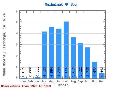
| Statistic | Jan | Feb | Mar | Apr | May | Jun | Jul | Aug | Sep | Oct | Nov | Dec | Annual |
|---|---|---|---|---|---|---|---|---|---|---|---|---|---|
| Mean | 0.07 | 0.00 | 0.11 | 4.13 | 4.55 | 4.40 | 5.03 | 3.62 | 3.12 | 2.73 | 1.47 | 0.49 | 2.49 |
| Standard Deviation | 0.12 | 0.00 | 0.26 | 1.42 | 1.68 | 2.39 | 3.23 | 1.93 | 1.59 | 0.71 | 0.39 | 0.28 | 0.90 |
| Min | 0.00 | 0.00 | 0.00 | 1.95 | 2.42 | 1.75 | 1.74 | 1.34 | 1.44 | 1.90 | 0.90 | 0.13 | 1.38 |
| Max | 0.40 | 0.00 | 0.83 | 6.42 | 8.35 | 8.67 | 11.60 | 8.59 | 8.24 | 4.06 | 2.11 | 1.14 | 4.62 |
| Coefficient of Variation | 1.65 | 3.74 | 2.38 | 0.34 | 0.37 | 0.54 | 0.64 | 0.53 | 0.51 | 0.26 | 0.26 | 0.58 | 0.36 |
 Return to R-Arctic Net Home Page