|
|
|||||||||||||||||
| Point ID: 6615 | Downloads | Plots | Site Data | Code: 9390 |
|
|
|||||||||||||||||
| Download | |
|---|---|
| Site Descriptor Information | Site Time Series Data |
| Link to all available data | |
| View: | Time Series | All |
| Units: | mm |
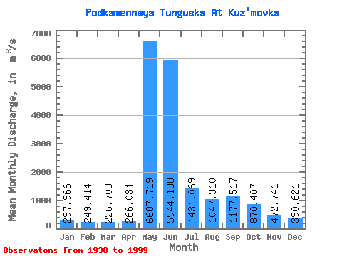
| Statistic | Jan | Feb | Mar | Apr | May | Jun | Jul | Aug | Sep | Oct | Nov | Dec | Annual |
|---|---|---|---|---|---|---|---|---|---|---|---|---|---|
| Mean | 297.97 | 249.41 | 226.70 | 266.03 | 6607.72 | 5944.14 | 1431.07 | 1047.31 | 1177.52 | 870.41 | 472.74 | 390.62 | 1587.18 |
| Standard Deviation | 70.78 | 55.79 | 50.16 | 119.86 | 1683.98 | 2549.11 | 434.43 | 444.34 | 478.31 | 368.25 | 133.78 | 106.08 | 247.21 |
| Min | 155.00 | 120.00 | 99.80 | 108.00 | 2790.00 | 2240.00 | 773.00 | 504.00 | 542.00 | 349.00 | 240.00 | 224.00 | 1136.83 |
| Max | 503.00 | 419.00 | 345.00 | 970.00 | 12000.00 | 15100.00 | 2800.00 | 3150.00 | 2540.00 | 2000.00 | 821.00 | 623.00 | 2315.58 |
| Coefficient of Variation | 0.24 | 0.22 | 0.22 | 0.45 | 0.26 | 0.43 | 0.30 | 0.42 | 0.41 | 0.42 | 0.28 | 0.27 | 0.16 |
 Return to R-Arctic Net Home Page