|
|
|||||||||||||||||
| Point ID: 6614 | Downloads | Plots | Site Data | Code: 9389 |
|
|
|||||||||||||||||
| Download | |
|---|---|
| Site Descriptor Information | Site Time Series Data |
| Link to all available data | |
| View: | Time Series | All |
| Units: | mm |
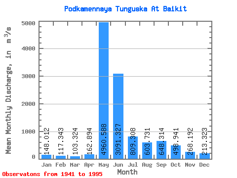
| Statistic | Jan | Feb | Mar | Apr | May | Jun | Jul | Aug | Sep | Oct | Nov | Dec | Annual |
|---|---|---|---|---|---|---|---|---|---|---|---|---|---|
| Mean | 148.01 | 117.34 | 103.32 | 162.89 | 4960.59 | 3091.33 | 809.31 | 603.73 | 648.31 | 498.94 | 268.19 | 213.32 | 974.46 |
| Standard Deviation | 55.60 | 49.01 | 44.90 | 192.25 | 1099.87 | 1761.46 | 292.75 | 297.62 | 306.83 | 274.43 | 107.04 | 90.44 | 209.75 |
| Min | 57.10 | 29.00 | 14.90 | 18.70 | 2760.00 | 922.00 | 390.00 | 246.00 | 287.00 | 170.00 | 116.00 | 72.80 | 619.00 |
| Max | 342.00 | 289.00 | 239.00 | 1400.00 | 7010.00 | 9940.00 | 1630.00 | 2010.00 | 1630.00 | 1370.00 | 707.00 | 517.00 | 1579.92 |
| Coefficient of Variation | 0.38 | 0.42 | 0.43 | 1.18 | 0.22 | 0.57 | 0.36 | 0.49 | 0.47 | 0.55 | 0.40 | 0.42 | 0.21 |
 Return to R-Arctic Net Home Page