|
|
|||||||||||||||||
| Point ID: 6613 | Downloads | Plots | Site Data | Code: 9388 |
|
|
|||||||||||||||||
| Download | |
|---|---|
| Site Descriptor Information | Site Time Series Data |
| Link to all available data | |
| View: | Time Series | All |
| Units: | mm |
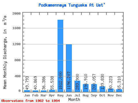
| Statistic | Jan | Feb | Mar | Apr | May | Jun | Jul | Aug | Sep | Oct | Nov | Dec | Annual |
|---|---|---|---|---|---|---|---|---|---|---|---|---|---|
| Mean | 49.79 | 40.87 | 36.39 | 55.54 | 1812.00 | 1196.21 | 283.90 | 196.91 | 200.06 | 139.83 | 80.22 | 65.31 | 346.83 |
| Standard Deviation | 24.21 | 18.59 | 16.59 | 49.07 | 549.89 | 642.68 | 130.85 | 98.35 | 97.75 | 80.31 | 37.31 | 31.03 | 82.68 |
| Min | 17.90 | 17.30 | 12.20 | 10.40 | 25.00 | 364.00 | 127.00 | 77.60 | 85.70 | 45.60 | 29.50 | 25.50 | 213.63 |
| Max | 127.00 | 98.80 | 82.00 | 250.00 | 2540.00 | 3730.00 | 633.00 | 440.00 | 460.00 | 401.00 | 169.00 | 159.00 | 583.92 |
| Coefficient of Variation | 0.49 | 0.46 | 0.46 | 0.88 | 0.30 | 0.54 | 0.46 | 0.50 | 0.49 | 0.57 | 0.47 | 0.47 | 0.24 |
 Return to R-Arctic Net Home Page