|
|
|||||||||||||||||
| Point ID: 6612 | Downloads | Plots | Site Data | Code: 9386 |
|
|
|||||||||||||||||
| Download | |
|---|---|
| Site Descriptor Information | Site Time Series Data |
| Link to all available data | |
| View: | Time Series | All |
| Units: | mm |
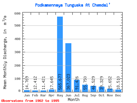
| Statistic | Jan | Feb | Mar | Apr | May | Jun | Jul | Aug | Sep | Oct | Nov | Dec | Annual |
|---|---|---|---|---|---|---|---|---|---|---|---|---|---|
| Mean | 14.77 | 12.41 | 11.42 | 17.64 | 565.68 | 367.02 | 91.43 | 55.75 | 46.53 | 39.33 | 25.65 | 18.51 | 106.05 |
| Standard Deviation | 5.49 | 4.55 | 4.66 | 16.01 | 146.17 | 199.99 | 59.31 | 34.55 | 22.76 | 19.10 | 12.17 | 7.19 | 22.64 |
| Min | 5.94 | 4.86 | 3.89 | 4.08 | 274.00 | 88.70 | 32.60 | 21.40 | 19.80 | 16.40 | 11.00 | 8.03 | 64.40 |
| Max | 28.20 | 22.80 | 23.80 | 88.50 | 791.00 | 1110.00 | 299.00 | 158.00 | 107.00 | 87.90 | 60.80 | 38.60 | 164.94 |
| Coefficient of Variation | 0.37 | 0.37 | 0.41 | 0.91 | 0.26 | 0.55 | 0.65 | 0.62 | 0.49 | 0.49 | 0.47 | 0.39 | 0.21 |
 Return to R-Arctic Net Home Page