|
|
|||||||||||||||||
| Point ID: 661 | Downloads | Plots | Site Data | Code: 07BE001 |
|
|
|||||||||||||||||
| Download | |
|---|---|
| Site Descriptor Information | Site Time Series Data |
| Link to all available data | |
| View: | Time Series | All |
| Units: | mm |
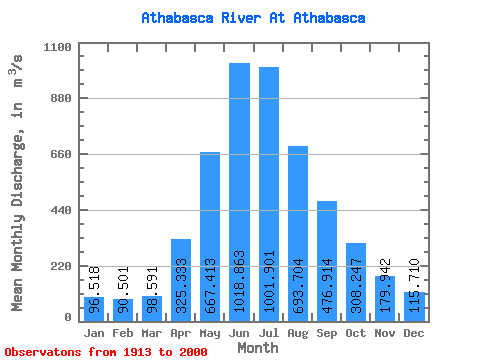
| Statistic | Jan | Feb | Mar | Apr | May | Jun | Jul | Aug | Sep | Oct | Nov | Dec | Annual |
|---|---|---|---|---|---|---|---|---|---|---|---|---|---|
| Mean | 96.52 | 90.50 | 98.59 | 325.33 | 667.41 | 1018.86 | 1001.90 | 693.70 | 476.91 | 308.25 | 179.94 | 115.71 | 428.80 |
| Standard Deviation | 25.11 | 22.33 | 27.50 | 172.36 | 342.37 | 343.43 | 312.11 | 190.58 | 173.29 | 94.30 | 49.74 | 37.84 | 90.22 |
| Min | 54.20 | 49.40 | 51.80 | 108.00 | 266.00 | 526.00 | 499.00 | 365.00 | 237.00 | 163.00 | 98.10 | 47.80 | 297.83 |
| Max | 156.00 | 140.00 | 209.00 | 973.00 | 2500.00 | 2280.00 | 2130.00 | 1460.00 | 1390.00 | 560.00 | 308.00 | 255.00 | 737.96 |
| Coefficient of Variation | 0.26 | 0.25 | 0.28 | 0.53 | 0.51 | 0.34 | 0.31 | 0.28 | 0.36 | 0.31 | 0.28 | 0.33 | 0.21 |
 Return to R-Arctic Net Home Page