|
|
|||||||||||||||||
| Point ID: 659 | Downloads | Plots | Site Data | Code: 07BC006 |
|
|
|||||||||||||||||
| Download | |
|---|---|
| Site Descriptor Information | Site Time Series Data |
| Link to all available data | |
| View: | Time Series | All |
| Units: | mm |
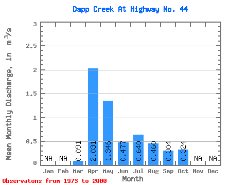
| Statistic | Jan | Feb | Mar | Apr | May | Jun | Jul | Aug | Sep | Oct | Nov | Dec | Annual |
|---|---|---|---|---|---|---|---|---|---|---|---|---|---|
| Mean | 0.09 | 2.03 | 1.35 | 0.48 | 0.64 | 0.46 | 0.30 | 0.32 | |||||
| Standard Deviation | 0.13 | 2.42 | 2.21 | 0.93 | 1.13 | 0.82 | 0.48 | 0.56 | |||||
| Min | 0.00 | 0.00 | 0.00 | 0.00 | 0.00 | 0.00 | 0.00 | 0.00 | |||||
| Max | 0.51 | 10.20 | 9.03 | 4.77 | 4.69 | 3.96 | 2.14 | 2.80 | |||||
| Coefficient of Variation | 1.40 | 1.19 | 1.64 | 1.95 | 1.77 | 1.78 | 1.56 | 1.74 |
 Return to R-Arctic Net Home Page